Mer de l'Ouest
A cartobibliography by Don McGuirk
ISBN-13: 978-0-9794768-8-4
 |
 |
|---|
Sorry! Mer de l'Ouest is out of print.
|
MapRecord Publications is pleased to announce the publication of The Last Great Cartographic Myth: Mer de l'Ouest, a digital-format cartobibliography, written by Don McGuirk. This is a groundbreaking work, not just in terms of being the first published cartobibliography covering the Mer de l'Ouest, but also in terms of being the first cartobibliography published in this electronic format.
Praise from reviewers Cartobibliographies tend to be quite weighty tomes, usually housed in special collections libraries, so it is a welcome development to receive McGuirk’s work in the format of a tiny flash drive … As a resource, it will be useful to those interested in the early exploration of the Americas, the drama of the Northwest Passage, and the persistence of cartographic fantasies. - Choice (Feb., 2012) I have no doubt that McGuirk's work will be valuable to anyone interested in the subject, and that the innovative format will be both improved and applicable to future cartobibliographies. Scholars, librarians, collectors and dealers familiar with the cost of recent printed cartobibliographies should be quite happy with the price of this publication. - Imago Mundi (Vol. 64:1, 2012) This work however is not simply a triumph of form over substance. McGuirk's book is a well researched presentation of all the maps that in any way protrayed the mythical Sea of the West. ... In the end, it is the high definition, zoomable maps that are the raison d'être for this book. It is in the maps that the new technology utilized shows its greatest potential. - The Portolan, (Winter, 2011) |
Cartobibliographies have been a vital source of information about antiquarian maps for collectors, researchers and map dealers. For example, no fewer than three cartobibliographies have been published about what is perhaps the best-known cartographic myth: California as an island. Throughout the 18th century another myth appeared on maps of North America: Mer de l'Ouest (Sea of the West), an imagined sea extending the navigable waters of the Pacific deep into the North American continent, at times nearly connecting the Pacific to Hudson Bay or the Great Lakes, and thereby promising the long sought for Northwest Passage from the Atlantic to the Pacific.
Don McGuirk has collected and researched maps that depict the Mer de l'Ouest, and he has now written a cartobibliography covering the entire history of this fascinating cartographic delusion. The cartobibliography lists 242 maps (many in multiple states), and most of the entries are accompanied by one or more high-resolution images.
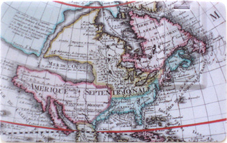
But this work is not your garden-variety cartobibliography. Instead of a print-format work, Mer de l'Ouest is produced in a digital format and distributed on a USB thumb drive, usable on any computer running the MS/Windows® operating system, (Windows/95 or later). Mer de l'Ouest can also be run on Macintosh computers with CrossOver; click here for information on running Mer de l'Ouest on a Mac. The thumb drive slides out of a credit-card sized carrying case (images of whose front and back are shown at the top of this page). There are a number of advantages to this digital format:
- Images are provided in high-resolution format. One of the biggest obstacles to publishers of print cartobibliographies is the high cost of providing large, high-resolution images of the maps described. With its digital distribution format, Mer de l'Ouest is able to provide nearly half a gigabyte worth of high-resolution imagery.
- Searching and sorting. Cartobibliographies typically have their entries sorted either chronologically or by map-maker. Often a title-index is also provided, and, on occasion, a geographic index. With the Mer de l'Ouest, you can search, sort or subset the entries using any of the provided fields, so locating a particular map or group of maps is extremely quick.
- Links to the internet. Mer de l'Ouest contains hundreds of links to further sources of information on the internet. These include additional high-resolution imagery from institutional collections (for example, images of additional states of a particular map), and library catalog citations from WorldCat®.
- Updates. If new information is uncovered about maps showing Mer de l'Ouest, MapRecord Publications will provide downloadable updates, which will keep the cartobibliography seamlessly updated to the latest findings. See the Mer de l'Ouest updates page for more information.
Mer de l'Ouest is more than just a list of maps. As with print cartobibliographies, Mer de l'Ouest comes with additional chapters (Preface, Acknowledgements, Introduction, etc.) that make this a fully-realized reference work. In an appendix, the author also provides the first English translation of J.N. De L'Isle's Nouvelles Cartes des Decouvertes de l'Amiral de Fonte, the 1753 essay that is a cornerstone in the development of the myth of a Western Sea.
The Last Great Cartographic Myth: Mer de l'Ouest was published in March, 2011. The purchase price is $45, plus $2 for shipping and handling. Purchase and payment are via PayPal, where you can either use a credit card or, if you have one, an existing PayPal account.
Sorry! Mer de l'Ouest is out of print.
|
Here are some sample screen shots from The Last Great Cartographic Myth: Mer de l'Ouest:
Initial Screen (Table of Contents):

The Introduction:

The Cartobibliography - list mode:

The Cartobibliography - details for a single item:

Image Windows: scaled mode and full-size mode:


NOTE: The Mer de l'Ouest USB flash drive runs under MS/Windows. It does not normally run on Macintosh computers, though it will run on newer Intel-based Mac systems that have Windows emulation software installed (such as CrossOver or Parallels). For a full description of how to run Mer de l'Ouest on a Mac with CrossOver, click here.